File list
From EGM Heritage
This special page shows all uploaded files.
| Date | Name | Thumbnail | Size | User | Description | Versions |
|---|---|---|---|---|---|---|
| 11:53, 29 July 2025 | History of electric power book.pdf (file) | 5.25 MB | Gcook | History of Electric Power in Manitoba, Credit Manitoba Hydro website | 1 | |
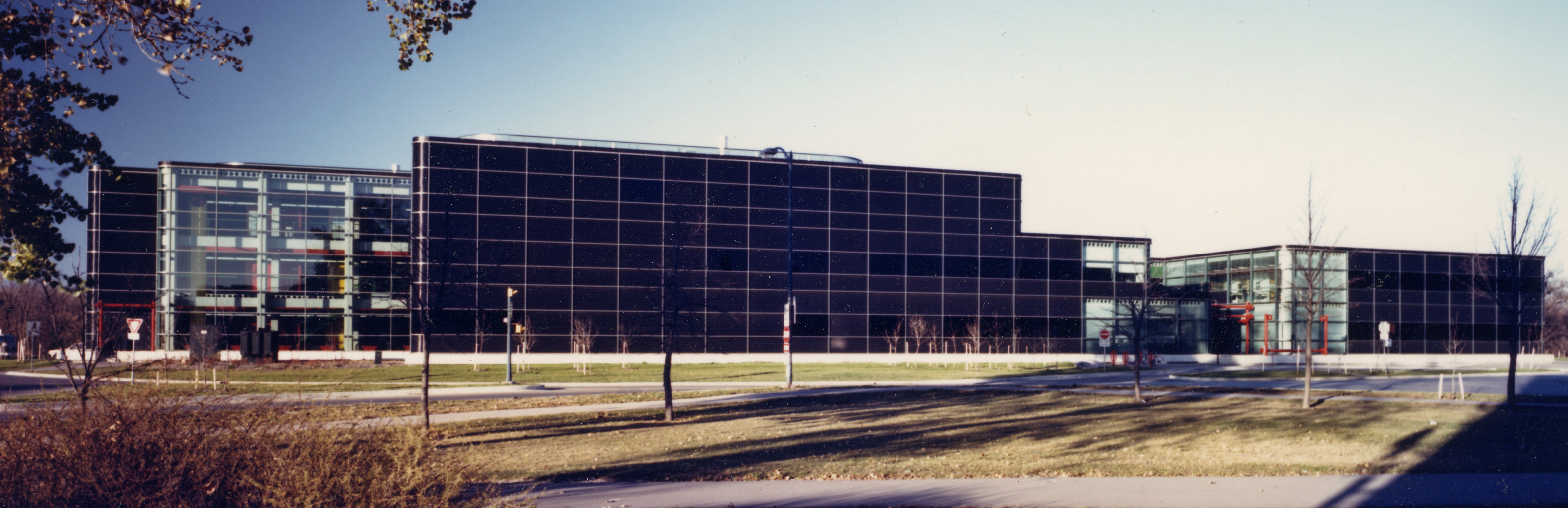
| 10:59, 29 July 2025 | Engineering & Information Technology Complex at the University of Manitoba,. Photo credit U of M, 2004.jpg (file) |  |
55 KB | Gcook | Engineering_&_Information_Technology_Complex_at_the_University_of_Manitoba,._Photo_credit_U_of_M,_2004 | 1 |
| 00:05, 24 July 2025 | A streetcar and pedestrians cross the Louise Bridge in the early 20th century. Source The Rob McInnes Postcard Collection Winnipeg Public Library.png (file) |  |
1.04 MB | Gcook | A streetcar and pedestrians cross the Louise Bridge in the early 20th century. Source The Rob McInnes Postcard Collection Winnipeg Public Library | 1 |
| 00:14, 23 July 2025 | Figure 4- Gas Lamps along early Winnipeg streets Photo credit Alan Aftanas, Manitoba Hydro Archives.jpg (file) |  |
24 KB | Gcook | Gas Lamps along early Winnipeg streets Photo credit Alan Aftanas, Manitoba Hydro Archives | 1 |
| 00:00, 23 July 2025 | Figure 3 b- Original wooden gas mains made from white pine logs Photo credit Alan Aftanas, Manitoba Hydro Archives .jpg (file) |  |
9 KB | Gcook | Figure 3 b - Original wooden gas mains made from white pine logs. Photo credit Alan Aftanas, Manitoba Hydro Archives. | 1 |
| 23:54, 22 July 2025 | Figure 3a - Original wooden gas mains made from white pine logs Photo credit Alan Aftanas, Manitoba Hydro Archives .jpg (file) |  |
11 KB | Gcook | Original wooden gas mains made from white pine logs. Photo credit Alan Aftanas, Manitoba Hydro Archives | 1 |
| 23:51, 22 July 2025 | Figure 2aGas Plant Location in downtown Winnipeg in the Point Douglas area circa 1884.jpg (file) |  |
176 KB | Gcook | Gas Plant Location in downtown Winnipeg in the Point Douglas area circa 1884 | 1 |
| 23:45, 22 July 2025 | Figure 2 - 1884 Birds Eye View of Winnipeg showing the Second Manufactured Gas Plant Location on Rachel Street - low resolution .jpg (file) |  |
356 KB | Gcook | Figure 2 – 1884 Birds Eye View of Winnipeg showing the location of the Second Gas Plant on Rachel Street. Map credit - Mortimer & Co. Lith. Ottawa. | 1 |
| 23:10, 22 July 2025 | Figure 1 - 1881 Birds Eye View of Winnipeg showing the First Manufactured Gas Plant Location in downtown Winnipeg in the Point Douglas area - see reference 66.jpg (file) | Error creating thumbnail: File with dimensions greater than 12.5 MP |
8.38 MB | Gcook | 1881 Birds Eye View of Winnipeg showing the First Manufactured Gas Plant Location in downtown Winnipeg in the Point Douglas area - see reference 66. Map credit - Mortimer & Co. Lith. Ottawa | 1 |
| 16:27, 15 April 2025 | PTH No 4f side view over the red river Curtis Walker photo used with permission 2025 02 03.jpg (file) |  |
60 KB | Gcook | PTH No 4 South Side view over the red river, Photo Credit - Curtis Walker Used with Permission, Copyrights | 1 |
| 15:29, 15 April 2025 | Bridge over the Saskatchewan River looking south 2024 07 21 Photo Credit Glen Cook.JPEG (file) |  |
780 KB | Gcook | Highway Bridge over the Saskatchewan River looking south 2024 07 21, Photo Credit Glen_Cook | 1 |
| 15:00, 15 April 2025 | Water power and Navigation Assiniboine River Report 1888 07 05 NH Ruttan City Wpg Engineer.pdf (file) | 1.64 MB | Gcook | Water Power and Navigation of the Assiniboine River Report 1888 07 05 by NH Ruttan City of Winnipeg Engineer | 1 | |
| 16:22, 14 April 2025 | Louise Bridge looking south towards Higgins 2019 06 06 GNC.JPG (file) |  |
585 KB | Gcook | Louise Bridge looking south towards Higgins 2019 06 06_GNC | 1 |
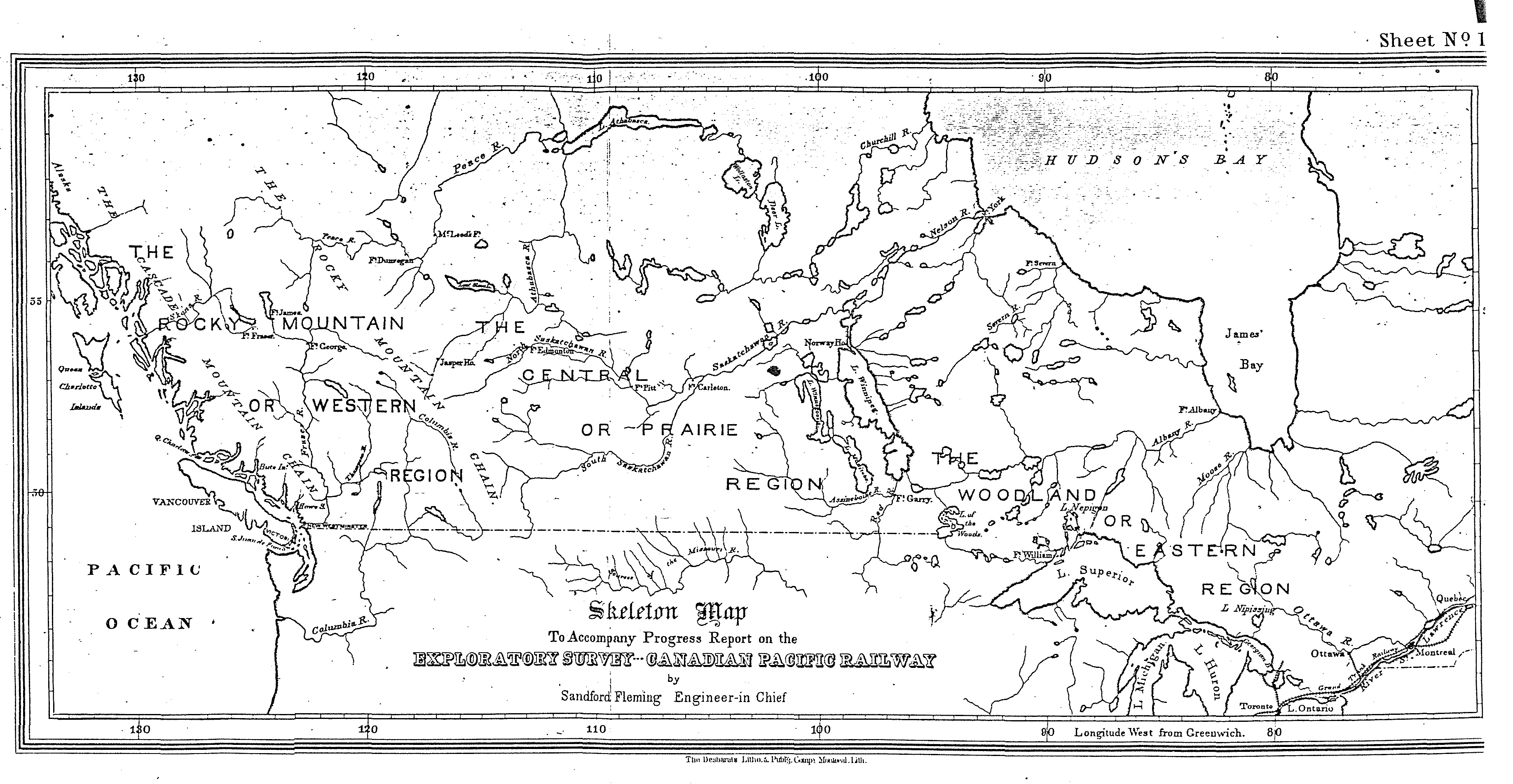
| 11:24, 4 April 2025 | Skeleton Map shewing the great divisions of the country to be traversed by the Railway.jpg (file) |  |
1.79 MB | Gcook | Skeleton Map shewing the great divisions of the country to be traversed by the Railway | 1 |
| 22:26, 2 April 2025 | Henry Norlande Ruttan - c1914 - Manitoba Archives.jpg (file) |  |
134 KB | Gcook | Henry Norlande Ruttan - c1914 - Manitoba Archives | 1 |
| 11:37, 14 March 2025 | Ganpat Lodha-2013 Photo Credit Amber Skrabek.jpg (file) |  |
499 KB | Gcook | Ganpat_Lodha-2013_Photo_Credit_Amber_Skrabek | 1 |
| 10:43, 28 February 2025 | Chronology of Winnipeg Bridges 2003 2004.pdf (file) | 55 KB | Gcook | Chronology_of_Winnipeg_Bridges_2003_2004, City of Winnipeg | 1 | |
| 10:38, 28 February 2025 | Broadway Bridge, seen here circa 1880 Archives of Manitoba.jpg (file) |  |
228 KB | Gcook | Edward Worrell Jarvis designed the Broadway Bridge, seen here circa 1880, that connected the Anglophone city of Winnipeg with its Francophone sister of St. Boniface across the Red River. Source: Archives of Manitoba, Letourneau 3, N11901 | 1 |
| 10:34, 28 February 2025 | First Assiniboine River Bridge (Main Street) with Upper Fort Garry in the background. built by the HBC 1881 SourceHBC Archives.jpg (file) | _with_Upper_Fort_Garry_in_the_background._built_by_the_HBC_1881_SourceHBC_Archives.jpg) |
103 KB | Gcook | First Assiniboine River Bridge (Main Street) with Upper Fort Garry in the background. built by the HBC 1881 Source HBC Archives | 1 |
| 12:34, 26 February 2025 | Geological Sciences logo.jpg (file) | 270 KB | Gcook | 1 | ||
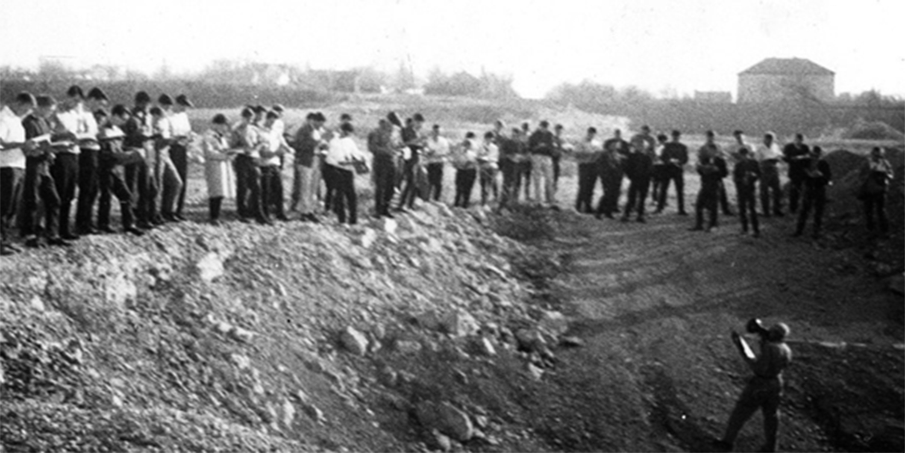
| 12:11, 26 February 2025 | 11 Earth Ring ceremony 2019.JPG (file) |  |
4.45 MB | Gcook | 2019 Earth Ring ceremony in the Ed Leith Cretaceous Menagerie. Photo credit - Department History Wall. | 1 |
| 12:10, 26 February 2025 | 10 Centenary at Star Lake Field Station 2010.jpg (file) |  |
1.23 MB | Gcook | Geological Sciences alumni, staff and friends celebrating the Department’s centenary at the Star Lake Field Station in August 2010. Photo credit - Department History Wall. | 1 |
| 12:10, 26 February 2025 | 9 Ed Leith Cretaceous Menagerie.JPG (file) |  |
2.95 MB | Gcook | The Ed Leith Cretaceous Menagerie, which was completed and dedicated in September 2003. Photo credit - Department History Wall. | 1 |
| 12:09, 26 February 2025 | 8 Wallace Building 1986.jpg (file) |  |
751 KB | Gcook | The newly constructed Wallace Building in 1986. Another one-and-a-half storeys were added in 2005 and 2012 to accommodate other units of the Clayton H. Riddell Faculty of Environment, Earth, and Resources. Photo credit - Department History Wall. | 1 |
| 12:08, 26 February 2025 | 7 Field school class 1971.jpg (file) |  |
2.18 MB | Gcook | Field school class of 1971 gathered on the verandah of the student bunkhouse. It has become a Department tradition to take the class photo here every year. Photo credit - Department History Wall. | 1 |
| 12:07, 26 February 2025 | 6 Star Lake Field Station 1971.jpg (file) |  |
1.59 MB | Gcook | The newly constructed Star Lake Field Station in 1971. The student bunkhouse is on the left; the kitchen and dining hall, which were also used as a classroom in the early days, are on the right. Photo credit - Department History Wall. | 1 |
| 12:06, 26 February 2025 | 5 Dominion Observatory vertical heat-flow hole being drilled to a depth of 606 m at the rear of the Geology Building 1964.jpg (file) |  |
681 KB | Gcook | Dominion Observatory vertical heat-flow hole being drilled to a depth of 606 m at the rear of the Geology Building in 1964. Photo credit - Department History Wall. | 1 |
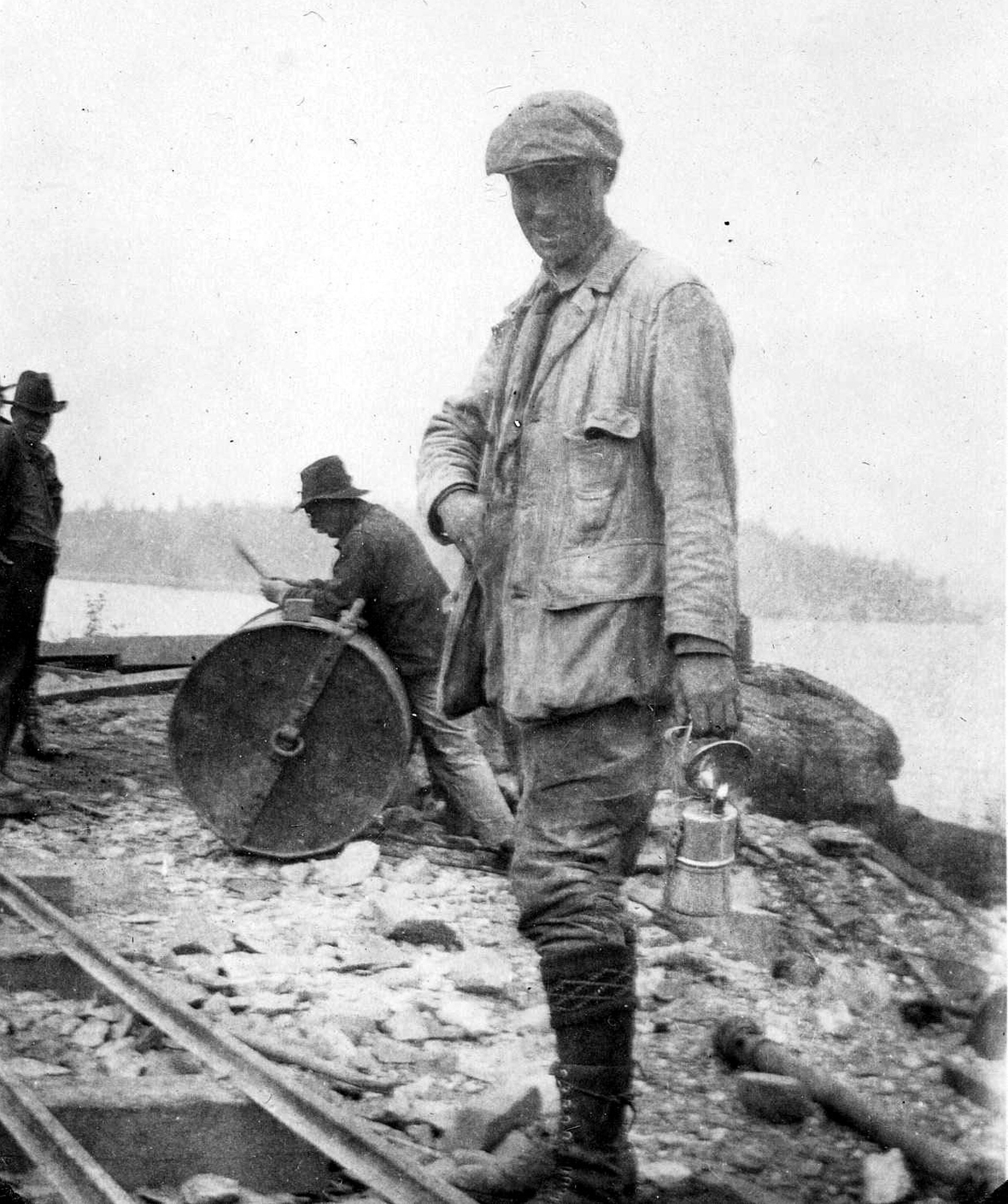
| 12:01, 26 February 2025 | 4 Department Regional gravity survey in northern manitoba 1960.jpg (file) |  |
630 KB | Gcook | Department regional gravity survey in northern Manitoba in 1960. Photo credit - Department History Wall. | 1 |
| 11:56, 26 February 2025 | 3 Edward Leith teaching Stratigraphy class at Stony Mountain quarry 1949.jpg (file) |  |
472 KB | Gcook | Edward Leith teaching a stratigraphy class at Stony Mountain in 1949. Photo credit - Department History Wall. | 1 |
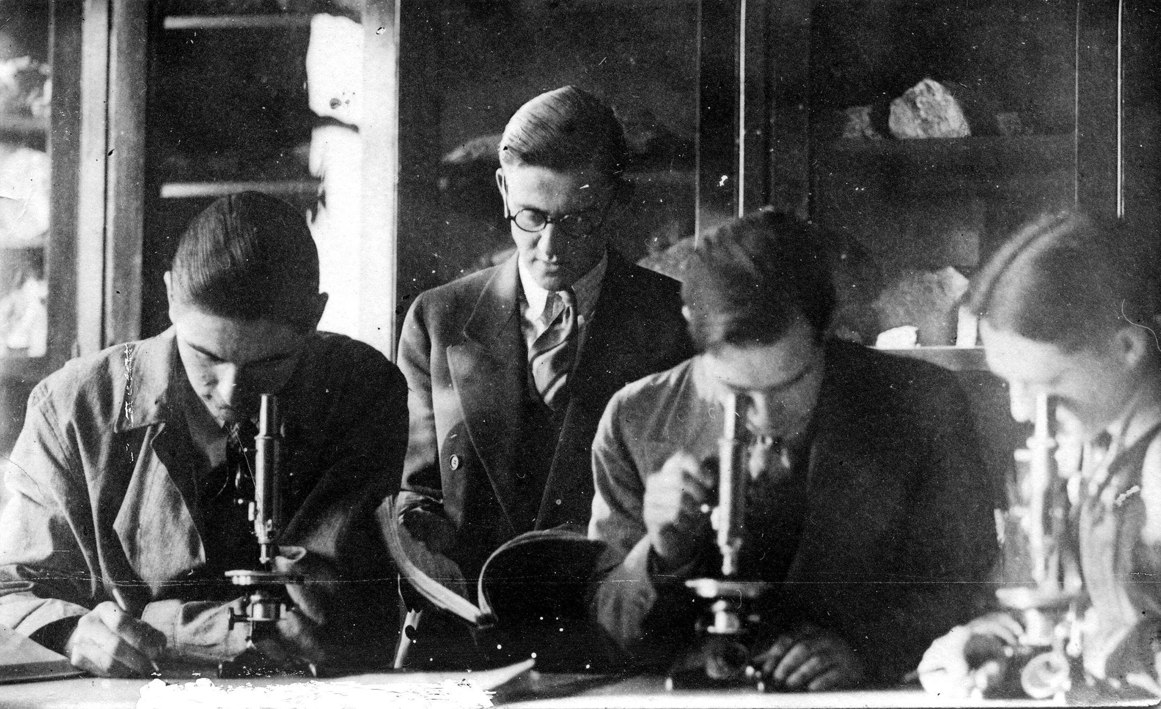
| 11:51, 26 February 2025 | 2 Geology Students Broadway Campus lab 1928.jpg (file) |  |
2.02 MB | Gcook | Geology students in a Broadway Campus laboratory in 1928 Photo Credit - Department History Wall. | 1 |
| 11:44, 26 February 2025 | 1 R.C. Wallace Flin Flon 1916.jpg (file) |  |
874 KB | Gcook | Dr. R.C. Wallace, first Head of the Department of Geology and Mineralogy, shown at Flin Flon in 1916. Photo Credit the Department’s History Wall. | 1 |
| 14:27, 24 February 2025 | Figure 5 Oil water gas Production Graphs Combined.jpg (file) |  |
1.48 MB | Gcook | Figure 5: Monthly production history between February 1951 and February 2019. (a) Cumulative monthly oil, water and gas production in the Virden Field. (b) Oil production by formation. Timing of significant discoveries, events and developments are indicated. Province of Manitoba | 1 |
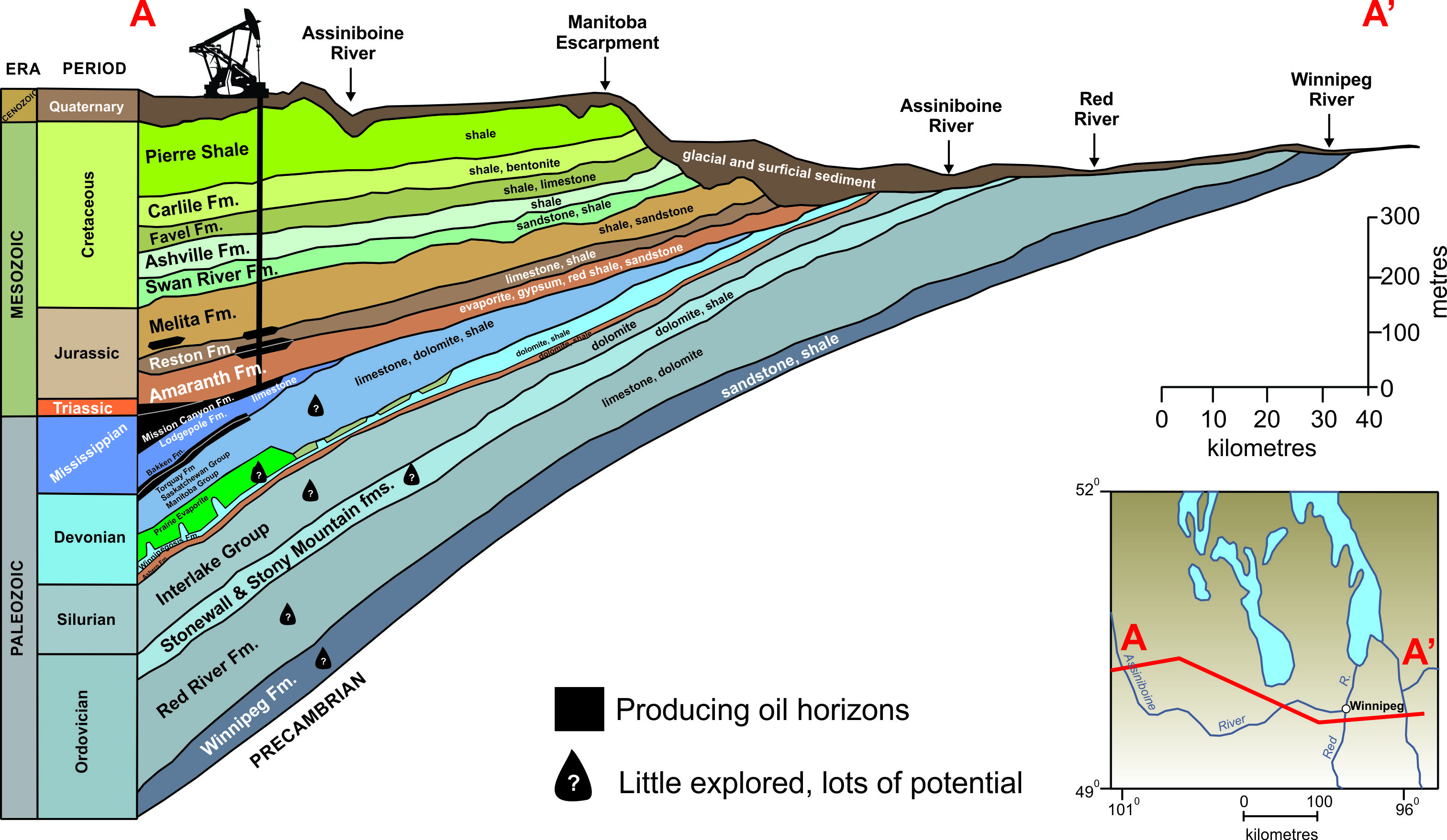
| 14:22, 24 February 2025 | Figure 4 SW Manitoba cross-section with oil pools.jpg (file) |  |
1.66 MB | Gcook | Figure 4: West to east cross-section of the Western Canada Sedimentary Basin in southern Manitoba. Formations with known oil pools are indicated with black infill; formations with no oil production but have good potential are indicated with an oil droplet. Province of Manitoba | 1 |
| 14:20, 24 February 2025 | Figure 3 Geological map of southwestern Manitoba showing the oil fields.jpg (file) |  |
1.55 MB | Gcook | Figure 3: Geological map of southwestern Manitoba showing the oil fields. The Mesozoic formations are hidden to show the underlying Mississippian formations and Devonian rocks. Province of Manitoba | 1 |
| 14:11, 24 February 2025 | Figure 2 Simplified stratigraphic Chart of Phanerozoic Rocks in southwester manitoba.jpg (file) |  |
1.39 MB | Gcook | Figure 2: Stratigraphic chart of the Phanerozoic rocks in southwestern Manitoba showing rocks ages, formations, and intervals with oil production and oil and gas shows. Blank (white) formation spaces indicate times with no rock record preserved. Province of Manitoba | 1 |
| 14:06, 24 February 2025 | Figure 1 Simplied MB geo map.jpg (file) |  |
1.93 MB | Gcook | Simplified Bedrock Map of Manitoba - Province of Manitoba | 1 |
| 13:53, 22 February 2025 | Figure 8 Hydraulic Testing Equipment; Workover Rig and or Umbilical Cable.jpg (file) |  |
773 KB | Gcook | Removed imbedded Figure name | 2 |
| 13:52, 22 February 2025 | Figure 7 Crosshole Seismic Image of the P-Wave Velocity between Borehole WB1 and WB2.jpg (file) |  |
365 KB | Gcook | Removed imbedded Figure name | 2 |
| 13:51, 22 February 2025 | Figure 6 Integrated Cross-Hole and Surface Radar Surveys at Grid Area ‘B’.jpg (file) |  |
896 KB | Gcook | Removed imbedded Figure name | 2 |
| 13:46, 22 February 2025 | Figure 5 Subsurface Models of Gravity & Magnetic Data from Whiteshell Research Area..jpg (file) |  |
472 KB | Gcook | Removed imbedded Figure name | 2 |
| 12:38, 22 February 2025 | Figure 2 Location of Grid, Sample and Detailed Study Areas Shown with simplified geology of Lac- du Bonnet Batholith within Whiteshell Research Area (WRA)..jpg (file) | ..jpg) |
1,001 KB | Gcook | Removed imbedded Figure name | 2 |
| 22:12, 3 February 2025 | CPR-Train-Pointe-line-Credit-City-of-Winnipeg-Hydro-Collection-Western-Canada-Pictorial-Index-University-of-Winnipeg.jpg (file) | Error creating thumbnail: File with dimensions greater than 12.5 MP |
1.16 MB | Gcook | CPR-Train-Pointe-line-Credit-City-of-Winnipeg-Hydro-Collection-Western-Canada-Pictorial-Index-University-of-Winnipeg | 1 |
| 22:11, 3 February 2025 | Pembina-Branch-RR-to-TB-CPR-Mainline-scaled.jpg (file) |  |
255 KB | Gcook | Pembina-Branch-RR-to-TB-CPR-Mainline-scaled | 1 |
| 22:10, 3 February 2025 | Joseph-Whitehead-1877-Credit-Archives-of-Manitoba-Collection-Western-Canada-Pictorial-Index-University-of-Winnipeg-scaled.jpg (file) |  |
531 KB | Gcook | Joseph-Whitehead-1877-Credit-Archives-of-Manitoba-Collection-Western-Canada-Pictorial-Index-University-of-Winnipeg-scaled | 1 |
| 22:08, 3 February 2025 | CPR-Mainline-between-Beausejour-Ingolf-LdB-Branch-scaled.jpg (file) |  |
107 KB | Gcook | CPR-Mainline-between-Beausejour-Ingolf-LdB-Branch-scaled | 1 |
| 22:08, 3 February 2025 | Corduroy-over-Muskeg-Credit-Hist-Folklore-Whiteshell-South-scaled.jpg (file) |  |
1.59 MB | Gcook | Corduroy-over-Muskeg-Credit-Hist-Folklore-Whiteshell-South-scaled | 1 |
| 22:07, 3 February 2025 | Arrival-of-Countess-of-Dufferin-Credit-Archives-of-Manitoba-Collection-Western-Canada-Pictorial-Index-University-of-W-1.jpg (file) |  |
1.26 MB | Gcook | Arrival-of-Countess-of-Dufferin-Credit-Archives-of-Manitoba-Collection-Western-Canada-Pictorial-Index-University-of-W-1 | 1 |
| 22:06, 3 February 2025 | Whitemouth-River-Bridge-circa-early-1900s-Credit-Western-Canada-Pictorial-Index-University-of-Winnipeg-scaled.jpg (file) |  |
416 KB | Gcook | Whitemouth-River-Bridge-circa-early-1900s-Credit-Western-Canada-Pictorial-Index-University-of-Winnipeg-scaled | 1 |
| 20:42, 3 February 2025 | Louise-bridge freeimages.com photographer tattooedmi-59788 -1446497.jpg (file) |  |
718 KB | Gcook | Louise-bridge_freeimages.com_photographer_tattooedmi-59788_-1446497 | 1 |
| 22:42, 2 February 2025 | View of the original Louise Bridge early 1880s by F. V. Bingham - Source Gordon Goldsborough, 2013-0094.jpg (file) |  |
37 KB | Gcook | View of the original Louise Bridge early 1880s by F. V. Bingham - Source Gordon Goldsborough, 2013-0094 | 1 |